— This site is still under construction —
The major turning point in the urban development of Saigon
is widely considered to be the French conquest beginning in 1859 and the establishment of French colonial rule, especially from the 1860s onward.
Why this is the key turning point
Before 1859, Saigon (Gia Định) was:
-
A regional trading town and military-administrative center under Vietnamese rule
-
Organized around canals, rivers, citadels, and villages, with organic, low-density development
-
Largely shaped by Confucian, Vietnamese, and Khmer spatial traditions
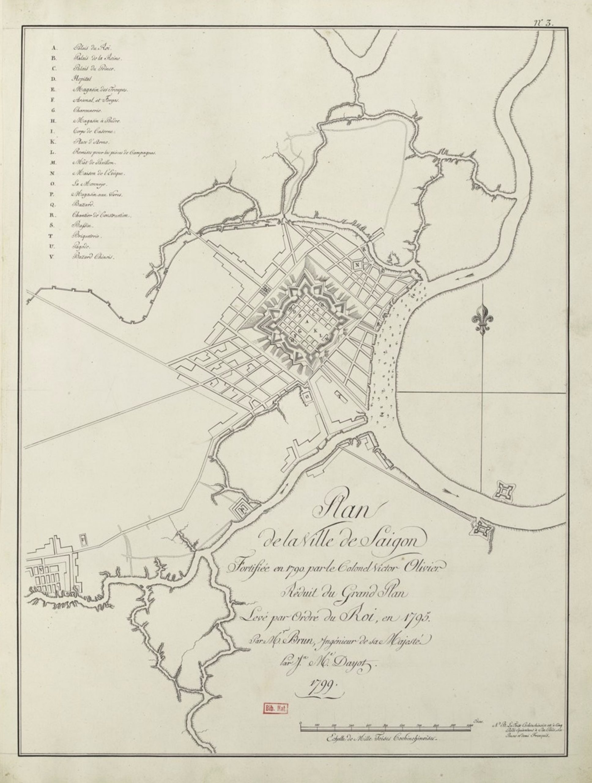
In 1788, Nguyễn Ánh captured the city, and used it as a centre of resistance against Tây Sơn. Two years later, a large Vauban citadel called Gia Định, or Thành Bát Quái („Eight Diagrams“) was built by Victor Olivier de Puymanel, one of the Nguyễn Ánh’s French mercenaries. The citadel was captured by Lê Văn Khôi during his revolt of 1833–35 against Emperor Minh Mạng. Following the revolt, Minh Mạng ordered it to be dismantled, and a new citadel, called Phụng Thành, was built in 1836. In 1859, the citadel was destroyed by the French following the Battle of Kỳ Hòa. Initially called Gia Định, the Vietnamese city became Saigon in the 18th century.
Saigon 1799
What changed under French rule (1860s–1945)
The French transformed Saigon into a planned colonial city, introducing features that still define Ho Chi Minh City today:
-
Western urban planning
-
Grid street system
-
Zoning (administrative, military, residential, commercial areas)
-
Public squares and boulevards (modeled on Paris)
-
Colonel Coffyn’s City Plan
Colonel Coffyn’s City Plan, commissioned by Admiral Bonnard, was presented on April 30, 1862, and approved on May 10. Ambitious, it encompassed, at the admiral’s request, the territories of Saigon and Cholon. However, the admiral himself realized that this plan, unrelated to the economic resources of the time, could not be implemented.
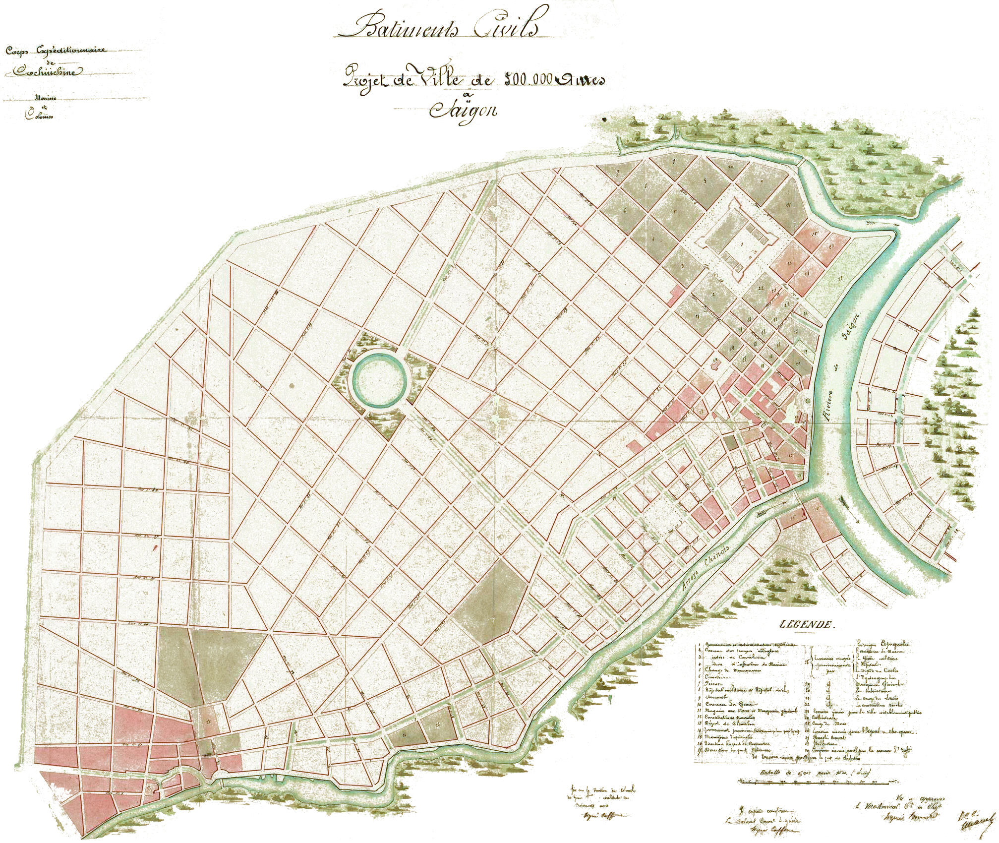
Bâtiments civils. Projet de ville de 500 000 âmes à Saigon, Author: Coffyn, Year 1862, Size 87 x 64 cm, Scale 1:10 000, Source: https://virtual-saigon.net/Maps/Source?ID=1267
Excerpt from Anne Burlat’s doctoral thesis, Institutional Processes and Urban Dynamics in the Contemporary Urbanization of Ho Chi Minh City, 1988-1998: Planning, Production, and Management of Housing Sectors, Lumière University Lyon 2, 2001. URL: http://theses.univ-lyon2.fr/documents/lyon2/2001/burlat_a#p=0&a=top
Saigon 1878
Plan de la ville de Saigon (Cochinchine) Year 1878 Edition Challamel Ainé Size 51 x 34 cm Scale 1:12 000 Comments La Cochinchine en 1878 par le comité agricole et industriel de la Cochinchine. Dressé par le chef du service des Travaux publics. Gravé par F. Dufour, 51 rue d’Assas. Imp. Dufrenoy, 34 rue du Four. Source
Modern infrastructure
-
-
Roads replacing canals
-
Sewer systems, electricity, piped water
-
Port facilities and rail connections
-
Colonial architecture
-
-
-
Notre-Dame Cathedral
-
Central Post Office
-
Opera House
-
Administrative buildings and villas
-
-
Saigon 1898
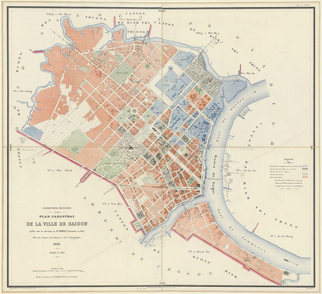
Cochinchine française. Plan cadastral de la ville de Saigon Author(s) M. Bertaux, Service du cadastre et de la topographie Cartographer(s) A. Chauvet Year 1898 Edition H. Barrère Size 65 x 60 cm Scale 1:4000 Comments Publié sous la direction de M. Bertaux; géomètre en chef, chef du service du cadastre et de la topographie. Réduit et dessiné par A. Chauvet, dessinateur du cadastre. Source
-
New urban function
-
Saigon became the capital of French Cochinchina
-
A political, economic, and cultural hub of colonial Indochina
-
Nicknamed the “Pearl of the Far East”
-
This period marks Saigon’s transition from a pre-modern Southeast Asian city to a modern colonial metropolis.
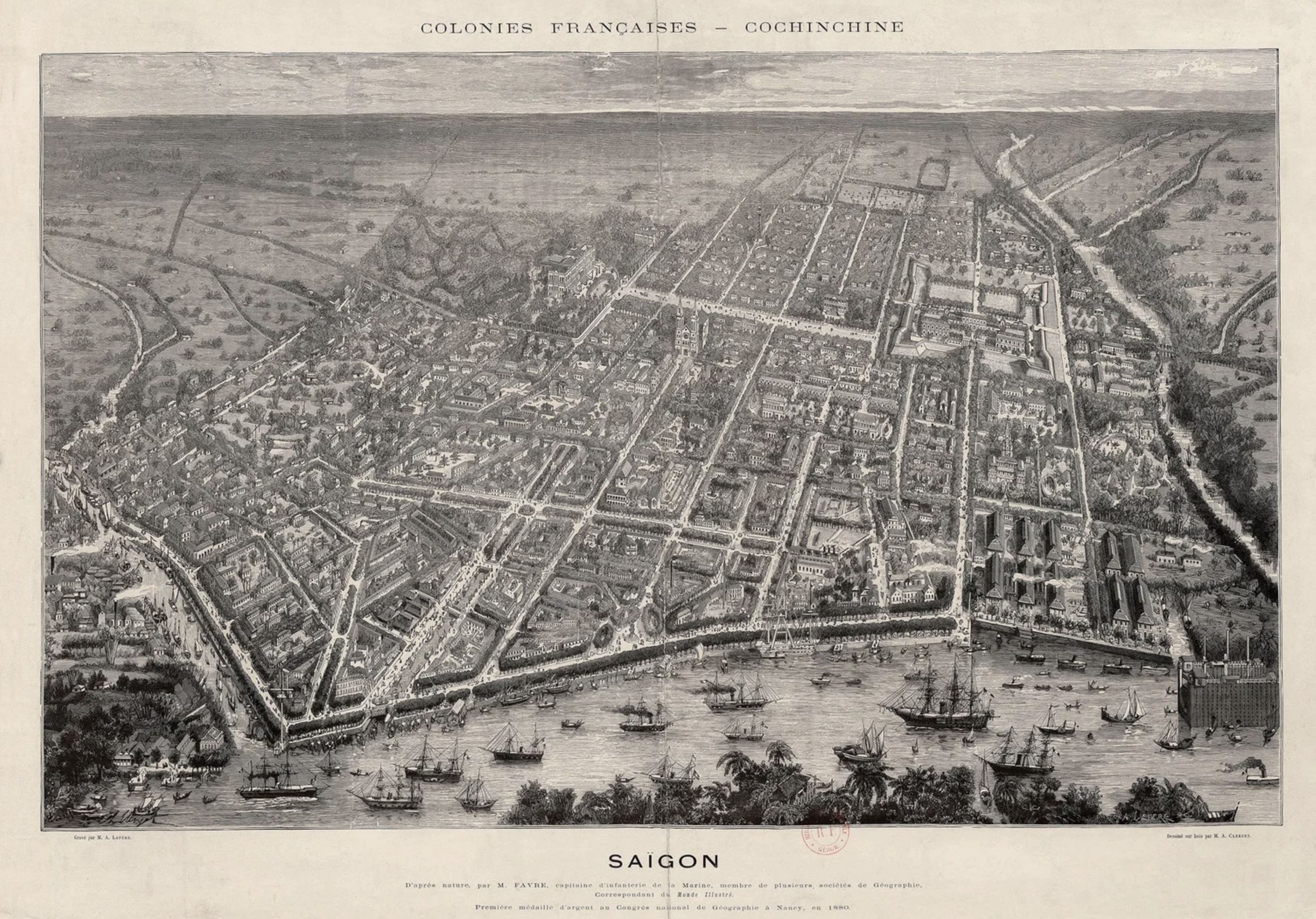
Saigon 1881 in der Vogelschau
Other important (but secondary) turning points
While the French period is the most decisive, other moments also mattered:
-
1954 (Geneva Accords) – Saigon becomes the capital of South Vietnam, triggering rapid population growth and suburban expansion
-
1975 (Reunification) – Saigon becomes Ho Chi Minh City; socialist planning and later market reforms reshape urban growth
-
Đổi Mới reforms (post-1986) – explosive urbanization, high-rise development, and global integration
Eastern Indochina 1963
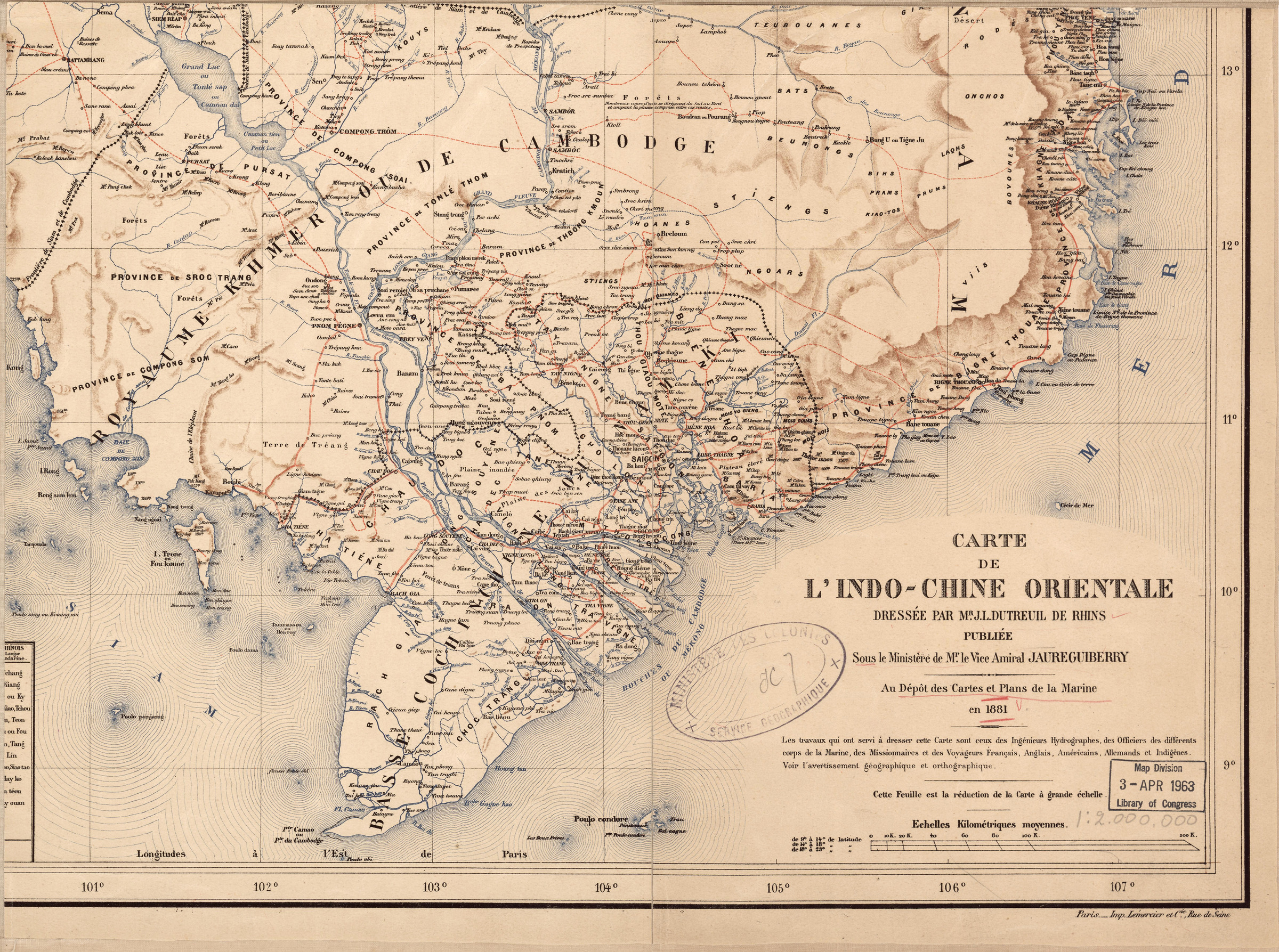
Carte de l’Indo-Chine Orientale (détail, Sud Vietnam), Alternative original title Khu vực miền Nam Việt Nam, Cartographer: J.L. Dutreuil de Rhins, Year 1881, Size 1: 200.000
Note at the bottom right of the map: At the Naval Map and Plan Depot in 1881. The work used to create this map was carried out by hydrographic engineers, officers of the various branches of the Navy, missionaries, and French, English, American, German, and Indigenous travelers. See the geographical and orthographic warning. Paris, Lemercier & Co. Printing House, Rue de Seine.
Stamp 1963 Map Collection. Library of Congress. Source: https://virtual-saigon.net/Maps/Source?ID=1659